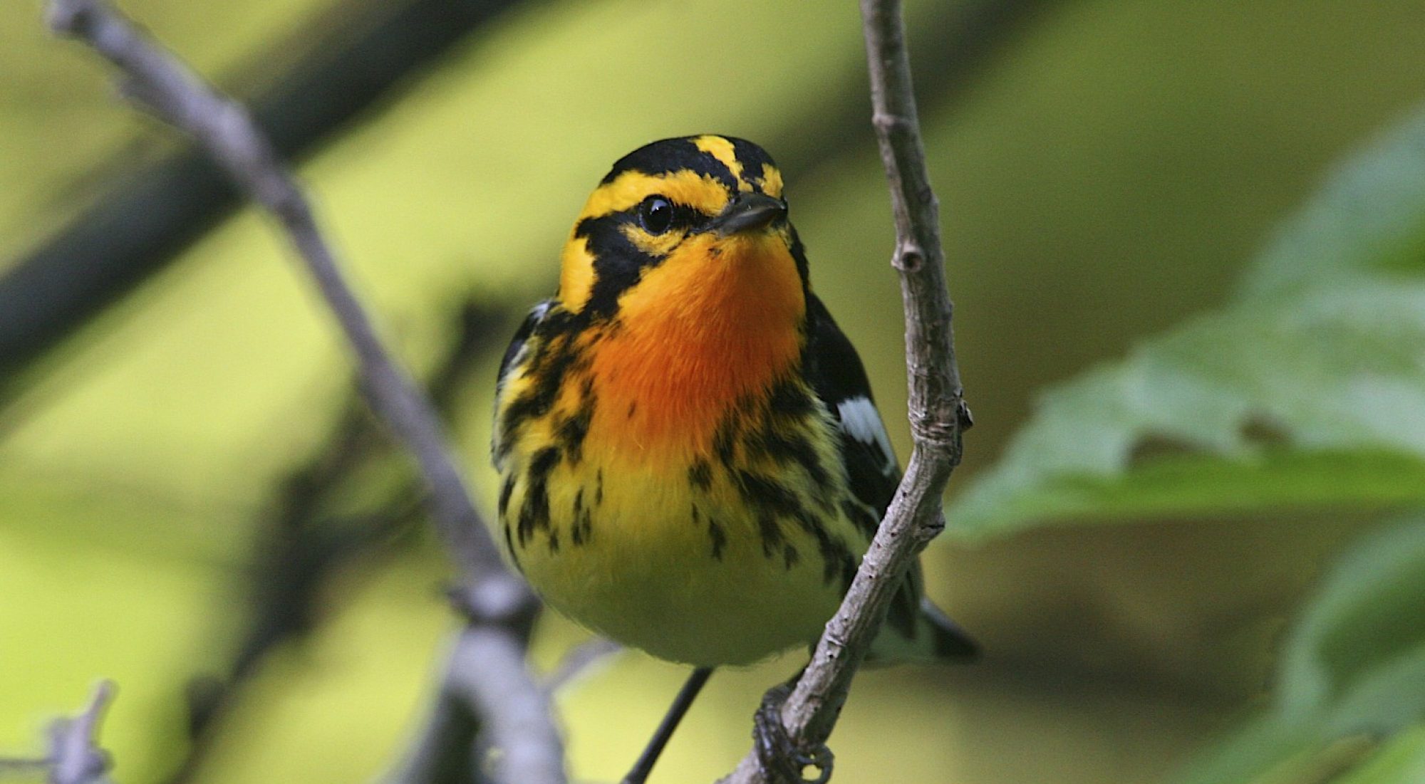
Our home base is Ulster County in the Hudson Valley of Upstate New York. We’re lucky to have wonderful birding not only in Ulster but in all the surrounding counties covering a wide variety of ecosystems. From forests and mountains to fields and streams, we have it all!
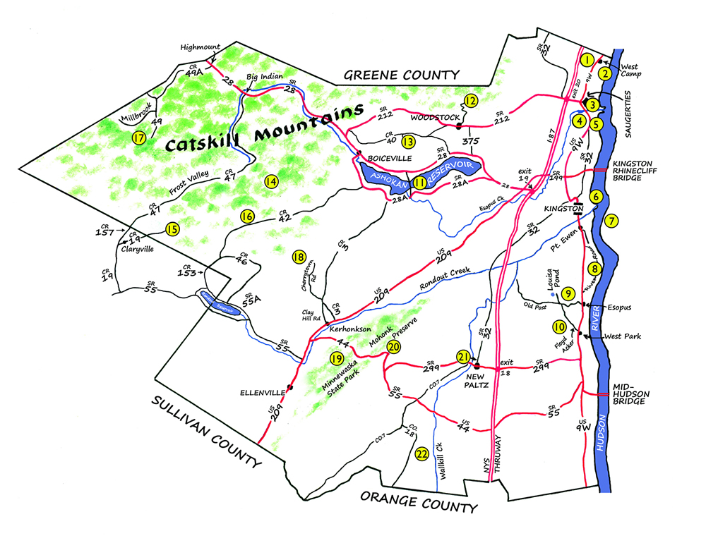
Select a number on the map to learn more about what you can find as well as GPS location and best time of year to visit. For the key to habitat and best time to visit please look below the map.
1. The Great Vly
2. Bristol Beach State Park
3. Saugerties Lighthouse Trail
4. Esopus Bend Nature Preserve
5. Falling Waters Preserve
6. Kingston Point
7. Sleightsburg Park
8. Esopus Meadows
9. Shaupeneak Ridge
10. Burroughs Sanctuary
11. Ashokan Reservoir
12. Overlook Mountain
13. Wilson State Park
14. Slide Mountain
15. Neversink East
16. Peekamoose Road
17. Balsam Lake Mountain
18. Vernooy Kill Falls Trail
19. Minnewaska State Park Preserve
20. Mohonk Preserve
21. Nyquist-Harcourt Wildlife Sanctuary
22. Shawangunk Grasslands NWR
1. The Great Vly
The Great Vly is a large freshwater marsh bordered by rock cliffs and wooded hills. Osprey, Golden Eagle, American Bittern, blackbirds, and thirty species of warblers pass through The Great Vly during spring migration. Common Nighthawks assemble in small flocks to rest and feed over the open marsh. Common and Black Terns have been observed in migration. Woodcocks, Swamp Sparrows, rails, and herons nest here, along with 3 species of vireos, warblers and other woodland birds. In late summer and early fall, unique floating mats of vegetation provide good shorebird habitat.
Directions: From the village of Saugerties drive north on US 9W through the hamlet of Malden to West Camp. Turn left (west) at West Camp Road and continue 1.2 miles to the short (unpaved) access road on the right, flanked by posts with NYS DEC signage.
Latitude, Longitude: 42°08’06″N, 73°56’40″W
WM UF | Sp Su F
2. Bristol Beach State Park
Bristol Beach State Park, in the Town of Saugerties, provides views of the Hudson River. Migrating passerines and waterfowl follow the river inland during spring and back to the coast in the fall. Among summer nesters are Eastern Bluebirds. Scan the river from an elevated parking area and walk quietly out on the peninsula to the south end, checking for waterfowl in the cove on the west side. Exposed mudflats in the cove attract herons, egrets, and shorebirds during low tide in late summer and early fall. Winter activity will vary based on ice conditions: watch for unusual species of gulls and a diverse array of waterfowl at first ice-out in late winter. Bald Eagles may be seen throughout the year.
Directions: Take US 9W north from the village of Saugerties, turn east onto Emerick Road (opposite Lauren Tice Rd) in Eavesport, just before entering West Camp. Follow Emerick Road 0.6 mile to the park.
Latitude, Longitude: 42°06’45″N, 73°55’35″W
TW UF | All
3. Saugerties Lighthouse Trail
Saugerties Lighthouse Trail is on a narrow spit of land at the confluence of the Hudson River and Esopus Creek in the village of Saugerties. Accessible at low tide, the 1/2-mile long trail passes through a stand of hardwoods, providing views of both the creek and the Hudson River, on the way to the Lighthouse. Migratory passerines find food and respite in the large trees; waterfowl congregate at the mouth of the creek in winter; herons, egrets, and shorebirds visit the tidal mudflats; and sparrows and wrens spend winter months in the reed thickets.
Directions: Follow US 9W north through the village of Saugerties. Where 9W curves sharply to the left, turn right onto Mynderse Street. Go 0.3 miles and turn left onto Lighthouse Drive. Go 0.4 miles to reach the lighthouse parking lot just after the US Coast Guard station. For additional information and directions visit http://www.saugertieslighthouse.com.
Latitude, Longitude: 42°04’22″N, 73°56’12″W
TW | Sp F W
4. Esopus Bend Nature Preserve
Esopus Bend Nature Preserve, on the banks of the Esopus Creek in Saugerties, is a 156-acre preserve with a northern hardwoods-hemlock forest, a transitional deciduous woodland, a semi-open meadow, emergent wetlands, and shallow and deep water coves. The Preserve is a valuable stop for migratory birds in both spring and fall and constitutes a significant wintering ground for a diverse array of birds, including a number of uncommon half-hardy species. For guided walks, see www.esopuscreekconservancy.org.
Directions: From US 9W, turn west on Overbaugh Street at the southern boundary of the village of Saugerties. Follow the signs to the preserve’s main entrance on Shady Lane or a secondary entrance on Kalina/Edgewood Drive.
Latitude, Longitude: 42°03’56″N, 73°57’30″W
WM UF M | All
5. Falling Waters Preserve
Falling Waters Preserve is a 168 acre Scenic Hudson (scenichudson.org) park featuring trailed access to a mile of Hudson River shoreline, second-growth woodlands, and extensive hayfield. Migratory songbirds and waterfowl are spring and fall attractions. Northern Harrier and Bald Eagles frequent the open fields and river in winter. Summer breeding birds include several species of warblers, vireos, woodpeckers, orioles, Scarlet Tanager, Indigo Bunting, and American Woodcock.
Directions: From US 9W, 3 miles south of the Village of Saugerties, turn east onto Josephs Drive and follow to Dominican Lane, or turn north onto York Street from CR 32 in Glasco and follow to Dominican Lane. Follow signs to parking area near end of road.
Latitude, Longitude: 42°02’53″N, 73°56’30″W
FS UF G | All
6. Kingston Point
Kingston Point includes Kingston Point Beach and Kingston Rotary Park on the Hudson River. From late fall to early spring, look for ducks, gulls, and bald eagles on the Hudson River and in the lagoon. Shrubbery around the edges of Rotary Park and the adjacent BMX course provide cover for winter sparrows, finches, and Carolina Wrens. From Rotary Park cross over the wooden bridge and follow the train tracks for views toward the Rondout Lighthouse, across the mouth of the Creek to Sleightsburg Spit, and into a shallow lagoon that was part of the Victorian-era Kingston Point Park.
Directions: From US 9W in Kingston, follow Delaware Avenue east and downhill until it ends at the Point. Park at the Beach (turn left) or by the BMX course.
Latitude, Longitude: 41°55'42"N, 73°57'54"W
TW FS | F W Sp
7. Sleightsburg Park
Sleightsburg Park, in Port Ewen, is a Town of Esopus park on a narrow spit of land on the south side of the mouth of Rondout Creek. Vireos, warblers and orioles nest in the canopy of deciduous trees. A large stand of cattails on the south side of the spit, that attracts Marsh Wrens and Least Bitterns, can be reached by canoe or kayak at high tide. In late summer, large numbers of Great Blue Herons and other wading birds congregate in Sleightsburg Bay at low tide.
Directions: From US 9W, just south of the Rondout Creek bridge, turn east at the traffic light and head north and downhill, turn right onto 1st Ave. for one block, left onto Everson St, and then right onto a gravel drive to the boat launch parking area. A foot trail leads east along the spit.
Latitude, Longitude: 41°55’10″N, 73°58’28″W
WM TW | Sp Su
8. Esopus Meadows
Esopus Meadows, in the Town of Esopus, is a shallow underwater shelf of the Hudson River offshore of Lighthouse Park and Esopus Meadows Preserve. Emergent river vegetation nurtures insects, small fish, and other food species that attract wading birds, waterfowl, and swallows during migration. In winter, look for ducks, Bald Eagles and Great Cormorants. The adjacent forest is a 100 acre Scenic Hudson preserve. It is a magnet for warblers and other passerines migrating along the river. Summer nesters include Worm-eating Warbler, Louisiana Waterthrush, and Scarlet Tanager. Five species of woodpeckers remain all year. A marked trail map is available at www.scenichudson.org/parks/esopusmeadows.
Directions: From US 9W in Port Ewen or Ulster Park, turn east onto River Road. Park at the Esopus Meadows Preserve at 275 River Road or the adjacent Lighthouse Park.
Latitude, Longitude: 41°52’07″N, 73°57’05″W
WM TW UF | All
9. Shaupeneak Ridge
Shaupeneak Ridge, in the Town of Esopus, has 500 acres of second-growth woodlands and a mountain-top pond with a bog. Passerines migrate along the ridgeline in spring. Vireos, Winter Wren, Ovenbird, Scarlet Tanager, Ruffed Grouse, and other woodland species nest throughout. Worm-eating Warbler and Louisiana Waterthrush prefer the east-facing slope.
Directions: There are two parking areas, one at the foot of the mountain and one by Louisa Pond. From US 9W, 5.8 miles north of CR 299, turn left onto Old Post Rd. The lower parking lot is 0.2 miles on the right. Access to Louisa Pond is 2.5 miles further: continue on Old Post Rd, at the intersection with Poppletown Rd, go straight ahead to the top of the ridge and the parking lot on the left. Foot trails go around the lake, to a Hudson River overlook, and join the two parking areas. A marked trail map is available at www.scenichudson.org/parks/shaupeneakridge.
Latitude, Longitude: 41°49’37″N, 73°58’13″W (Lower lot)
WM OW UF | Sp Su
10. Burroughs Sanctuary
Burroughs Sanctuary, in the Town of Esopus, is the site of Slabsides, the rustic cabin retreat of the famous late 19th and early 20th century naturalist, John Burroughs. The Sanctuary consists of 192 acres on a wooded hillside, with several trails and a large pond. Migrating passerines visit in the spring; lowland woodland and “edge” species—Wood Thrush, Scarlet Tanager, Eastern Bluebird—nest here. An osprey or bald eagle may visit the pond, which is also a good place to study dragonflies and damselflies. The Sanctuary is open dawn to dusk daily, year round. For more information about John Burroughs himself, visit: http://research.amnh.org/burroughs.
Directions: From US 9W in the hamlet of West Park, turn west on Floyd Ackert Road, cross the railroad tracks, go 1/2 mile and turn left onto Burroughs Road. Go 3/10 mile up the hill and park along the road near the entrance gate.
Latitude, Longitude: 41°47’50″N, 73°58’18″W
WM OW UF | Sp Su
11. Ashokan Reservoir
Ashokan Reservoir, about 12 miles long, fills two large basins in the towns of Olive and Hurley. Bald Eagles can be seen year round and a pair of Eagles has nested near the southern end of the dividing weir since 1999. Passerines forage in the winter and nest in the summer in the wooded areas around the aeration basin. In winter, as long as there is open water, loons, grebes, ducks and gulls are present. Walking and biking are permitted on the East Dyke and on Monument Road along the West Basin. Parking is available at three sites along CR 28A: at the Aeration Basin, the “donut” at the east end of the Dyke, and the west end of Monument Rd. Access to the shore and the water is limited to individuals with fishing licenses and permits. All other access is prohibited. The Reservoir is closely monitored by guards from the NYC Department of Environmental Protection, and visitors must remain only in the areas permitted by the NYCDEP.
Directions: From Exit 19 of I-87 in Kingston, take SR 28 west 12 miles to the village of Shokan. Turn left at Winchell’s Corner onto Reservoir Road and drive 4 miles to the southern end of the dividing weir. Turn left and follow the road downhill. To park at the “donut,” take the first left fork onto SR 28A, go about 1-1/2 mile and turn left into the driveway for the parking area. To park at the Aeration Basin, take the first right fork after the weir onto SR 28A, and turn right into the parking area. Continue on SR 28A for about 3 miles to reach the parking area at Monument Road.
Latitude, Longitude: 41°56’53″N, 74°12’15″W (Aeration Basin)
OW UF | All
12. Overlook Mountain
Overlook Mountain Wild Forest is a 590 acre area within the Catskill Forest Preserve. A two mile long route climbs to the top of the mountain where there is a fire tower and a restored firewatcher’s cabin. Migrating and nesting warblers and other montane species can be seen and heard along the red-blazed route. On weekends in good weather, the top of the fire tower is open and there are exhibits in the firewatcher’s cabin.
Directions: From SR 212 in the center of Woodstock, take Rock City Rd then Meads Mountain Rd north for two miles to the trailhead parking at the crest of the hill.
Latitude, Longitude: 42°04’15″N, 74°07’21″W
M UF | Sp Su
13. Wilson State Park
Wilson State Park is surrounded by beautiful mountains and panoramic views and is a popular camping destination. The “off” season is the best time for a birder to visit the park; the walking is easy and good habitat is accessible on the paved camping loops and maintained trails that follow the meandering Little Beaver Kill. The park is known for resident Ruffed Grouse and breeding Alder Flycatchers, but can also be an exciting location during spring migration when many birds will feed on aquatic born insects near the beaver impoundment. In flight years, winter finches are likely, especially redpolls foraging in the alders.
Directions: From Kingston proceed 5.9 miles on Rt. 28, turn right on Old Rt. 28 then right again on Ohayo Mountain Road (Cty. Rt. 41), turn left on Glenford/Wittenberg Road (Cty. Rt. 40) and continue 4.5 miles to park entrance on the left. Address: 859 Wittenberg Road, Mt. Tremper, NY 12457
Latitude, Longitude: 42°01’30″N, 74°13’01″W
UF WM | Sp W
14. Slide Mountain
Slide Mountain, at 4,180 feet, is the Catskill’s highest peak and the site of the original discovery of Bicknell’s Thrush. The peak is reached via a moderately difficult 2.8-mile foot trail. At higher elevations there is an extensive balsam fir-red spruce boreal forest where Bicknell’s Thrush, Swainson’s Thrush, Blackpoll Warbler, White-throated Sparrow, and Yellow-bellied Flycatcher nest. The lower elevation deciduous forest hosts numerous species of breeding thrushes, warblers, woodpeckers, and Scarlet Tanager, Winter Wren, and Yellow-bellied Sapsucker. Crossbills, Pine Grosbeaks, and rarely Boreal Chickadee are potential winter invasion species.
Directions: Take SR 28 west of Kingston to Big Indian. Turn left onto CR 47 and continue 8.5 miles through the valley and uphill. After a hairpin curve, look for the Slide Mountain parking area on your left just past Winnisook Lake which is the headwaters of the Esopus Creek.
Latitude, Longitude: 42°00’43″N, 74°24’53″W
UF M | Sp Su W
15. Neversink East
Neversink East, in the Town of Denning, encompasses the headwaters of the east branch of the Neversink River. A mile and a half on an old road (Phoenicia-East Branch trail, blazed yellow, to Peekamoose-Table trail, blazed blue) offers a mountain experience, with minimal effort, through dense stands of conifer and mixed deciduous forest. Eight Catskill High Peaks, including four trail-less summits, are directly accessible from the stream valley for the more ambitious.
Deciduous-forest birds breed in summer, and the river valley funnels high-elevation forest species during spring and fall migration. Common Redpolls and Pine Siskins can be found in impressive numbers during the winter months, and Pine Grosbeaks and Crossbills are likely in invasion years.
Directions: From the Slide Mountain trailhead, continue 16 miles on CR 47 through Frost Valley and to Sullivan County. Briefly enter Sullivan County where Ulster CR 47 changes to Sullivan CR 157, turn left on CR 19 toward Claryville, following Denning Road for 7.9 miles to the NYS DEC trailhead at the end of the road.
Latitude, Longitude: 41°57’55″N, 74°27’08″W
M UF | All
16. Peekamoose Road
Peekamoose Road provides easy access to montane habitat with waterfalls, mountain streambeds, and steep rocky slopes along a paved road in the towns of Olive and Denning. This is a breeding area for a variety of low elevation woodland birds and for Acadian Flycatchers at their northern-most range limit.
Directions: Take SR 28 west of Kingston, before entering Boiceville turn left onto SR 28A. In approximately 3 miles, turn right onto CR 42/ Peekamoose Road. In 3.7 miles, the road enters state land. For the next 8 miles, until the hamlet of Sundown, there are pull-offs, trailheads, and other parking areas to stop, look, and listen.
Latitude, Longitude: 41°54’53″N, 74°25’44″W
M UF | Sp Su
17. Balsam Lake Mountain
Balsam Lake Mountain, at 3,720 feet, offers many of the same species that can be found on Slide Mountain. An old jeep road provides a moderate three-mile hike, followed by a short, steep climb on a foot trail, to a fire tower on the summit. There is extensive fir-spruce boreal forest in the upper elevations and a semi-open habitat at the foot of the tower. Blackpoll Warbler is common near the summit and Mourning Warbler may be found at mid-elevations.
Directions: Take SR 28 west of Kingston to Highmount. Turn left onto CR 49A and go past the Belleayre State Ski Area. Follow CR 49A (about 6 miles on Galli-Curci and Todd Mountain roads), turn left onto CR 49 (Dry Brook Rd), go approx. 1-1/2 miles and turn right onto Millbrook Road. Continue about 2 miles to the trailhead parking area on the right. The trail is across the road and uphill.
Latitude, Longitude: 42°04’24″N, 74°34’42″W
M UF FS | Sp Su
18. Vernooy Kill Falls Trail
Vernooy Kill Falls Trail, in the Sundown Wild Forest in the Town of Denning, provides hiking access to Vernooy Kill Falls and to Balsam Swamp, a unique and extensive balsam fir-mountain laurel swamp and sphagnum moss bog. A 1.8-mile walk from the Cherrytown trailhead crosses two streams and gains 600 ft. elevation to reach the falls. There are two other trailheads: one from Yeagerville Rd in Greenville, and another from Trails End Rd. Balsam Swamp is nearer the Greenville trailhead. Blackburnian, Black-throated Blue, Canada, Yellow-rumped, and Hooded warblers nest in the laurel and hemlock thickets along the trail. Veery, Hermit Thrush, Yellow-bellied Sapsucker, and several species of vireos and flycatchers breed in the surrounding forest. Northern Waterthrush, White-throated Sparrow, and Dark-eyed Junco breed in the swamp.
Directions: At the traffic light in Kerhonkson, on US 209, turn northwest onto Clay Hill Rd. Go 1.5 mile and merge left onto CR 3 for 1/10 mile. At the Pine Grove Resort, turn left onto Cherrytown Rd, following the current route of the Long Path (aqua blazes). In 3.7 miles, turn left onto Upper Cherrytown Rd and continue for 3.1 miles to the NYSDEC parking lot on the right. The trail, following the Long Path, starts across the road.
Latitude, Longitude: 41°51’38″N, 74°20’52″W
UF WM | Sp Su
19. Minnewaska State Park Preserve
Minnewaska State Park Preserve protects 12,000 acres of the Shawangunk Ridge in the towns of Rochester and Wawarsing. Many species of warblers and other woodland birds nest on the ridge. One route for seeing and hearing them is an 8-mile loop trail from Minnewaska Lake via the Hamilton Point and Castle Point Carriageways. Less strenuous is the short walk on the park road between the main entrance and the Awosting parking lot. In 1998, the first Peregrines to return to the Shawangunks after the DDT crisis nested on the cliffs of Millbrook Mountain. The trail from Gertrude’s Nose to Millbrook offers excellent perches to watch for Peregrines and for migrating raptors.
Directions: From New Paltz (exit 18, I-87) drive west on SR 299 to the intersection of US 44/SR 55. Turn right and continue 4 miles to the main entrance, on the left. There is a per vehicle entry fee. Drive up the hill and park near Minnewaska Lake.
For more information call 845-255-0752 or visit their website.
Website: www.nysparks.com
Latitude, Longitude: 41°44’06″N, 74°14’19″W
UF FS | Sp Su F
20. Mohonk Preserve
Mohonk Preserve, on the Shawangunk ridge west of New Paltz, spans 8,000 acres in adjacent corners of the towns of Gardiner, Rochester and Marbletown. It is a private, non-profit organization dedicated to protecting the Shawangunk ridge and its habitats. Its trails are open to members and visitors, with a day use fee for non-members. Guests of the Mohonk Mountain House Hotel have free access to the Preserve’s trails. There are several areas of the Preserve that can be especially rewarding for bird-watching. The open fields at Spring Farm have a large population of nesting Indigo Buntings. Duck Pond hosts many woodland and “edge” species of warblers, plus Wood Thrushes, Scarlet Tanagers, and usually an Acadian Flycatcher. More montane species, like Slate-colored Juncos, Blackburnian Warblers, and Winter Wrens, nest on the north-facing slopes of Rock Rift. The ridge now supports nesting Peregrines, Ravens, and Black and Turkey vultures. There is a Hawk Watch at the Near Trapps in the Fall.
Directions: The visitor center for Mohonk Preserve is located on US 44/NY 55, about 1/2 mile north of the western terminus of SR 299. Maps and information can be obtained there or by calling 845-255-0919.
Website: www.mohonkpreserve.org.
Latitude, Longitude: 41°44’10″N, 74°11’08″W
UF FS WM | Sp Su F
21. Nyquist-Harcourt Wildlife Sanctuary
Nyquist-Harcourt Wildlife Sanctuary is on the floodplain of the Wallkill River at the western edge of the village of New Paltz. The sanctuary, owned by the Thomas & Corrine Nyquist Foundation, is open to the public. There is a pleasant trail (which may be flooded after heavy rains) through a grassy meadow and stands of water-loving trees. Marsh species–Sora Rail, Snipe, Empidonax flycatchers and even a Sedge Wren have been found here. Orioles and Common Yellowthroats nest. In the fall, many sparrows visit the Community Gardens adjacent to the Sanctuary. On autumn nights listen for Great Horned and Screech Owls. Bluebirds and woodpeckers stay all winter.
Directions: Heading west through New Paltz on Main St. (SR 299), turn right (north) just before the bridge over the Wallkill River. Take the first left toward the water treatment plant, and park in the public lot. Walk north along the river past the Community Gardens to enter the sanctuary.
Website: www.nyquistfdtn.org/nyquist-harcourt-wildlife.html
Latitude, Longitude: 41°45’00″N, 74°05’20″W
FS WM | All
22. Shawangunk Grasslands NWR
Shawangunk Grasslands National Wildlife Refuge is on the site of the old Galeville Airport in the Town of Shawangunk. The refuge is part of the Wallkill River National Wildlife Refuge and is managed for grassland species of concern and for protection of the watershed of the Wallkill River. Bobolinks, Eastern Meadowlark, Eastern Bluebird, Upland Sandpiper, and Vesper, Grasshopper and Savannah sparrows nest, as historically have Henslow’s sparrows. Winter brings Rough-legged Hawks, Northern Harriers, and Short-Eared Owls. In early spring, American Woodcocks perform their twilight courting flights.
Directions: From SR 299 west of New Paltz, turn south on CR 7 (Libertyville Rd and then Brunswyck Rd) to CR 18 (Hoagerburgh Rd). The entrance and parking area is on CR 18 between Long Lane and Bates Lane. Also, drive through nearby Blue Chip Farm on Bates Lane, about 1.5 miles south via CR 18, to look for Longspurs and Horned Larks in winter and for Red-headed Woodpeckers all year.
Website: http://www.fws.gov/refuge/shawangunk_grasslands/
Latitude, Longitude: 41°38’11″N, 74°13’10″W
G FS | Sp Su W
Habitat
FS – field/shrubs G – grasslands M – montane OW – open water TW – tidal wetlands UF – upland forest WM – wetland/marsh
Best time to visit
Sp – spring Su – summer F – fall W – winter All – every season
Please also reference the John Burroughs Checklist of Ulster County Birds which includes the relative seasonal abundance and preferred habitat of 277 species recorded in Ulster County, NY, with an additional 30 species listed as accidental or lacking adequate documentation. Report unusual bird sightings in Ulster County to UCBirds@surbirder.com. For additional resources please visit www.ebird.org. Launched by The Cornell Lab of Ornithology at Cornell University and the National Audubon Society, eBird gathers basic data on bird abundance and distribution. A web interface allows participants to submit their observations or view results via interactive queries of the database.
Map drawn by Jack Fagan